Emergency service personnel from the Gold Coast have been deployed to the state’s Far North ahead of the arrival of Tropical Cyclone Narelle.
Narelle strengthened to a category four system overnight and was sitting about 500 km east northeast of Cooktown on Thursday morning.
Forecasters expect Narelle to remain a category four before crossing the coast between Cape Melville and Lockhart River on Friday morning.
The Bureau is warning that Narelle will pack a real punch as it makes landfall.
“As the cyclone crosses the coast, we could see peak, very destructive wind gusts in excess of 230km/h close to the core of the system, with broader areas of destructive gusts up to 160km/h an hour between Lockhart River and Cooktown,” Christie Johnson from the Bureau said.
“Heavy to intense rainfall will also build in this tropical cyclone warning area through today, more likely from tonight, continuing into Friday morning, and flash flooding will become an increasing concern as the cyclone draws near.
“Abnormally high tides, which may lead to inundation of low-lying areas, are expected to develop along the far north Queensland coast as Narelle approaches and crosses the coast.”
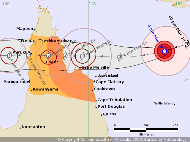
Image: BOM
Police, paramedics, SES and fire crews have been deployed to the region with personnel from the Gold Coast among those already on the ground.
Swiftwater rescue teams are among those spread across the state’s Far North as they await landfall tomorrow.
They are there, and they’ll be actively watching, and as the system moves closer, and as different resources are needed in different locations, the concentration of staff across a broad area puts us in good stead to be able to respond quickly,” Premier David Crisafulli said.
“Obviously, we’re asking people to do the right thing and limit the need for those rescues, but it’s really important to know that they have been prepositioned.”