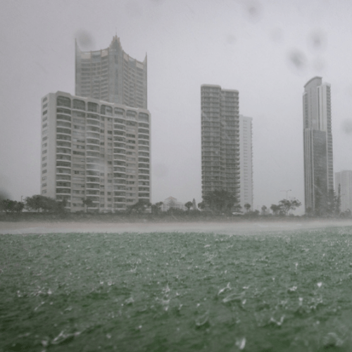
UPDATE @ 5.30pm Friday, Feb 13 | City officials are urging Gold Coasters to stay alert this evening as the rain continues.
Council’s latest alert is urging residents to monitor conditions for potential flash flooding from heavy rainfall forecast this evening and into Saturday morning.
It warns the rainfall could be intense at times, increasing the risk of flash flooding, especially in urban and low lying areas and rapid runoff over dry ground may cause localised flash flooding.
There is the potential for minor to moderate flooding of Gold Coast rivers and creeks and the Albert Logan River catchment.
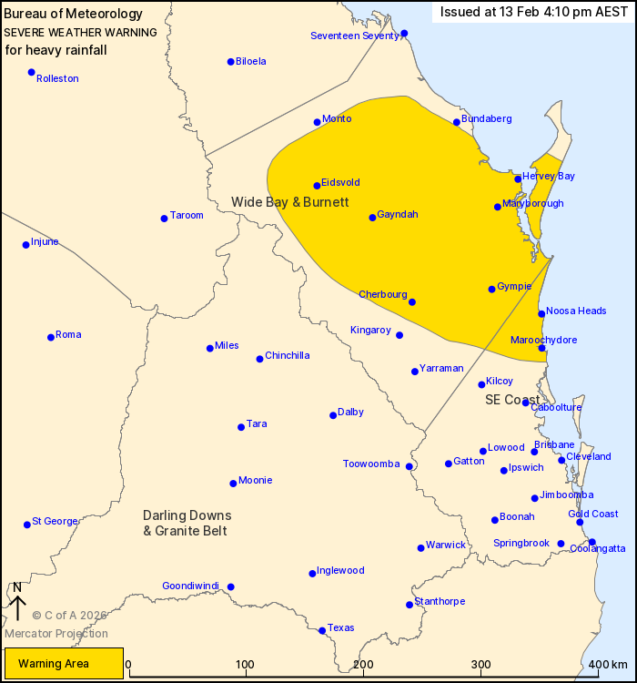
Earlier @ 4.00pm | The Gold Coast is no longer included in the severe weather warning for the south east, as the wilder weather starts to shift further north.
The Bureau of Meteorology warns a trough lying across the south east is still capable of producing heavy falls this evening. However, there is large uncertainty with where the areas of highest rainfall will occur. Rainfall is likely to broadly ease later tonight, but local heavy falls may be possible into the weekend.
Locations which may be affected include Maroochydore, Gympie, Noosa Heads, Hervey Bay, Cherbourg and Gayndah.
The Gold Coast has seen significant falls, particularly through the morning, with 157mm recorded at Tallebudgera Creek in the 6 hours to 11:35am and 188 mm was recorded at Currumbin Creek in the 6 hours to 10:21am.
Earlier @ 3.30pm | More than 2,500 homes and businesses on the Gold Coast are without power, as the downpours continue.
The worst of the outages are around Helensvale, Hope Island and Coomera due to powerlines coming down along Hope Island Road. Emergency services are currently on scene working to clear the scene.
However, there are also separate outages through Tallai and Witheren.
Energex is working to fix the issue.
EARLIER | Gold Coasters are being reminded not to drive through floodwaters, with several roads across the city now being impacted by heavy rain.
The warning comes after a vehicle attempted to drive through the flooded Hardys Road in Mudgeeraba around 9am on Friday before stalling and getting stuck, sparking a rescue operation.
The behaviour has infuriated local authorities, with Disaster Co Ordinator Mark Ryan describing those who continue to defy the warnings as selfish.
“It’s extremely frustrating because what they’re doing is putting our emergency services at risk,” Ryan said.
“So as soon as that vehicle was detected within the centre, we then had our fire and rescue and our police discussing how to resource that incident.
“That’s also police resources that could be dedicated to another incident across the Gold Coast.
“It’s completely avoidable and we just ask people to make good decisions when it comes to water across the road”.
As of 1pm, 12 roads were impacted across the Gold Coast including:
- Tallebudgera Connection Road, Tallebudgera
- Bermuda Street, Burleigh Heads
- Hardys Road, Mudgeeraba
- Highfield Drive, Merrimac
- Vince Hinde Drive, Worongary
- Mount Cougal Road, Tallebudgera Valley
- Gunsynd Drive, Mudgeeraba
- Stewarts Road, Currumbin Waters
- Currumbin Creek Road, Currumbin Valley
- Gold Coast Springbrook Road, Mudgeeraba
- Berrigans Road, Mudgeeraba
- Somerset Drive, Mudgeeraba
The wet weather is expected to continue to intensify throughout the day before easing overnight, however showers will continue across the weekend.
“A southerly wind change has moved into Southeast Queensland today,” the Bureau of Meteorology said.
“This combined with high atmospheric moisture and a mid-level trough is likely to produce areas of heavy rainfall.
“There is large uncertainty with where the areas of highest rainfall will occur. Rainfall is likely to broadly ease later tonight, but local heavy falls will remain possible into the weekend.”
Six-hourly rainfall totals between 50 to 100 mm are likely, with isolated higher falls to around 150mm possible.
It comes after 169mm was recorded at Currumbin Valley in the 6 hours to 10:21am on Friday.
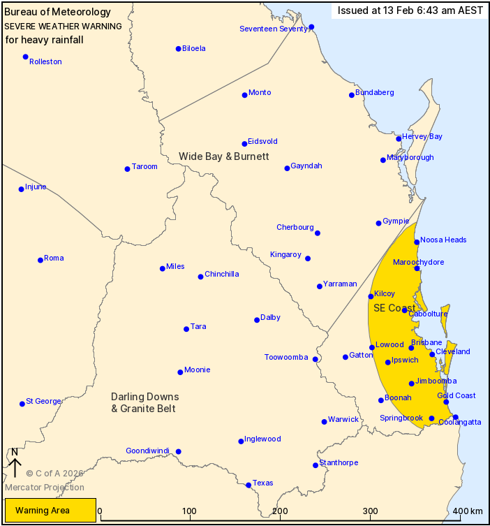
UPDATE @ February 13, 6.30 AM | Gold Coasters are being told to prepare now for potential localised flooding from heavy rainfall.
A severe weather warning is in place, as well as a flood watch for our rivers and creeks, as heavy rain sets in across the city.
More than 240 millimetres has been forecast to fall from today through to Sunday, with some parts already copping between 30 to 60 millimetres overnight.
“However, today we are likely to see rain and storms continuing with the risk of heavy falls that could lead to flash flooding,” Meteorologist Miriam Bradbury said.
“That rain is expected to build gradually over the coming hours but storms are more likely from the late morning going into the afternoon”.
Bradbury said the severe weather warning covers the Gold Coast and Gold Coast hinterland all the way down to the NSW border.
“It’s flagging six hourly rainfall totals up to 90mm with possible isolated high falls up to 150mm… this is quite a lot of rain to fall in a short space of time and most likely it will be too fast to drain away and that’s when we get those flash flooding impacts”.
“It’s definitely a risk that people on the Gold Coast should be aware of today.”
The weather bureau said severe thunderstorms are also likely to develop within the warning area, which could see higher rainfall totals in a shorter space of time.
The wet weather is expected to continue across the weekend, but the heaviest falls are expected today.
“Saturday and Sunday will see showers continuing, but we’re unlikely to see the high numbers we’re looking at today,” Bradbury said.
“But we still are likely to see rain coming into the gauges and it’s that accumulation over multiple days which may lead to the riverine flooding across our rivers and waterways,
“So just be aware that even if we’re not seeing too much on the radar right now we may still be feeling the impacts across those those rivers and waterways”.
The wild weather isn’t expected to ease until late Sunday, so lovebirds with plans for a romantic outdoor picnic for Valentines Day will need to make other arrangements!
UPDATE @ 5.00PM, Thursday, February 12 | The Bureau of Meteorology has updated its severe weather warning for the Gold Coast, warning of the possibility of more than a month’s worth of rain in just six hours.
A southerly change will move into the south east overnight and into Friday morning before stalling over southern Wide Bay and Burnett during Friday afternoon and evening.
At the same time, an approaching mid-level trough combines with high atmospheric moisture and humid onshore flow to produce persistent rainfall over parts of the south east coast southern Wide Bay and Burnett and eastern Darling Downs and Granite Belt from Thursday evening.
“Heavy, locally intense rainfall which may lead to dangerous and life-threatening flash flooding is forecast to develop from late Thursday evening, extending inland to southern Wide Bay and Burnett and eastern Darling Downs and Granite Belt during Friday morning,” the BOM warning states.
“Six-hourly rainfall totals between 50 to 90mm are likely, with isolated higher falls to around 150mm possible, reaching up to 200mm near the coast.”
EARLIER @ 1:30PM, Thursday, February 12 | A severe weather warning has now been issued for the Gold Coast ahead of several days of heavy rain, due to begin tonight.
Thunderstorms are expected to hit the region later on Thursday, ahead of a cool change and a trough that is expected to linger over the southeast.
“A southerly wind change will move into the South East Coast overnight Thursday into Friday morning, before stalling over the Wide Bay and Burnett during Friday afternoon/evening,” The BOM has warned.
“Meanwhile, an approaching mid-level trough combines with high atmospheric moisture and humid onshore flow to produce persistent rainfall over parts of the South East Coast, southern Wide Bay and Burnett and eastern Darling Downs and Granite Belt from Thursday evening.”
Heavy rain is expected to hit the region and continue into Friday, which may lead to dangerous and life-threatening flash flooding.
Rainfall totals of 270mm are expected over the next three days, but some areas could see isolated totals in excess of 400mm.
A floodwatch has also been issued for Gold Coast rivers and creeks, as well as the Logan and Albert Rivers.
“Catchments are relatively dry within the Flood Watch area, which may initially slow the response to rainfall, however river level rises, and areas of flooding are likely across the Flood Watch area.
“Minor to moderate flooding is possible from Friday and over the weekend, with rapid river level rises and isolated major flooding a possibility in areas that receive the heaviest rainfall.”
A separate floodwatch is also current for the New South Wales Northern Rivers, with the BOM warning of the potential for minor flooding along the Tweed River.
Ahead of the expected downpour, Gold Coast Council has opened sandbagging stations today only.
They will be open until 6pm at the following locations:
- 42-44 Boyd Street, Bilinga (next to City of Gold Coast Tugun Depot)
- 196 Old Pacific Highway, Pimpama (next to the City of Gold Coast Coomera Depot)
- Carrara Sports Precinct Parking, via Alabaster Drive, Carrara (self-service)
EARLIER | A flood watch has been issued for parts of the northern Gold Coast ahead of a weekend drenching.
The wet weather system is expected to make its way up to the southeast by Friday, dumping as much as 270 millimetres of rain over the next three days.
Residents living near the Logan and Albert Rivers have already been put on alert, with an initial flood watch for possible ‘minor flooding’ issued for the area.
“A trough will move east over southern and central Queensland from Thursday and linger for the remainder of the week, drawing deep tropical moisture more broadly across the state and enhancing shower and storm activity over multiple days,” the weather bureau said.
“Moderate to heavy falls are likely across the Flood Watch area from later Thursday.
“Catchments are relatively dry within the Flood Watch area which may initially slow the response to rainfall. However, river level rises and areas of localised flooding are likely across the Flood Watch area.
“Minor flooding is possible from Friday and into the weekend, with rapid river level rises and moderate flooding also a possibility in areas that receive the heaviest rainfall”.
The Bureau of Meteorology said the situation will be monitored closely as there is “significant uncertainty in the location and timing of the heaviest falls, particularly from Saturday onwards”.
The catchments likely to be affected include:
Dawson and Don Rivers
Burnett River
Mary River
Upper Brisbane River
Logan and Albert Rivers
Condamine Rivers
Balonne River
Lower Brisbane River (Bremer River, and Warrill, Lockyer, Laidley, Ipswich and Brisbane creeks only)