Live updates:
4.30 PM | Update on Gold Coast schools
The majority of schools across the Gold Coast will remain closed on Tuesday, with many still being too unsafe to allow students to return.
There were more than 100 public, independent and Catholic schools across the Gold Coast listed as being closed on the Queensland School Closures website.
Individual schools have been contacting parents to inform them of the closures.
You can check your school here: Queensland School Closures
4.00 PM | Update on city services
A number of city services will remain suspended on Tuesday in the aftermath of the weather disaster. All libraries and community centres will remain shut with the exception of:
- Upper Coomera Library and Community Centre
- Broadbeach Library and Community Centre
- Nerang Library
- Palm Beach Community Centre (Aquatic Centre remains closed)
- Robina Auditorium, Library and Community Centre
Park, playgrounds, sporting fields, all aquatic centres and customer service centres remain shut.
Bin collection resumed on Monday while temporary skip pins have been placed in areas where collections haven’t been able to resume.
Many waste centres are also open again including at Pimpama, Reedy Creek, Helensvale, Molendinar, Springbrook and Numinbah Valley.
2.45 PM | Incredible footage released of damage to Gold Coast beaches
Hats off to our amazing SES crews who continue to work tirelessly across the Gold Coast attending to hundreds of jobs.
The SES has released this incredible aerial footage of the erosion on Gold Coast beaches, plus some of the great work our SES teams are doing.
Video: SES
1.30 PM | Gold Coast flood threat reduced

Finally some promising news for the Gold Coast, with Council downgrading its Watch and Act alert for the city.
“City of Gold Coast advises people on the Gold Coast that the FLOOD THREAT IS REDUCED,” Council said.
“Rainfall has eased. Take care when returning to the area as flood damage can be widespread”.
More information on current Gold Coast warnings here.
1.20 PM | Gold Coast Titans relocate interstate after flooding decimates Parkwood training base
The Gold Coast Titans have been forced to pack their bags and fly to Sydney early ahead of their season season opening clash against the Bulldogs this weekend.
It comes after the club’s training fields at Parkwood were inundated by flooding in the aftermath of ex Tropical Cyclone Alfred.
More on this story here.
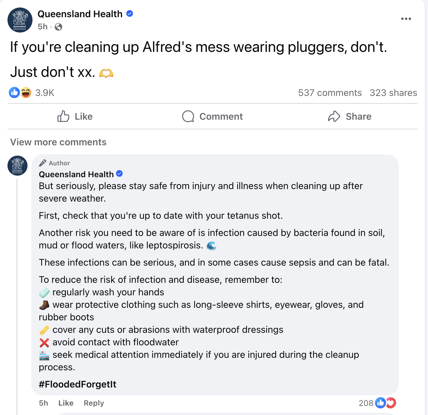
1.00 PM, March 10 | Gold Coasters reminded of the dangers lurking in floodwaters
With the rain across the Gold Coast finally easing, residents are being reminded of the health risks associated with floodwaters as the mammoth clean up task begins.
Queensland Health with this humorous but very valid reminder:
12.25 PM, March 10 | PM announces disaster payments for workers, businesses impacted by Alfred
Prime Minister Anthony Albanese has revealed workers and sole traders in Queensland and NSW who have lost income as a direct result of the cyclone will be able to access income support.
The Disaster Recovery Allowance will “provide up to 13 weeks of income support at a Jobseeker level to individuals who work in local government areas impacted,” Albanese said.
Applications will open from 2pm tomorrow, with the PM saying workers able to check their eligibility by logging into MyGov or by visiting the Services Australia website.
12.00 PM, March 10 | First wave of disaster payments announced
The Premier has revealed there will be hardship payments made available for residents affected by the significant weather event.
David Crisafulli confirmed the “first wave” of payments will be for people on the Gold Coast, the Redlands and in Logan.
“That’s the payments of $180 per person, $900 per family,” the Premier said.
“That’s the first wave and other impacted areas will come on.”
Support includes a range of grants to assist with the purchase of emergency essentials, the replacement of damaged household items, and income-tested assistance for property structural repairs and the reconnection of essential services.
Personal Hardship Assistance Scheme
- Emergency Hardship Assistance Grants – $180 per person, up to $900 for a family of five or more to purchase immediate essentials like food, clothing and medicine.
- Essential Services Hardship Assistance – $150 per person, up to $750 for a family of five or more to assist with immediate needs following the loss of essential services at home for more than five consecutive days.
- Essential Household Contents Grants – up to $1,765 for individuals and up to $5,300 for couples or families to replace destroyed essential household contents such as bed linen and white goods.
- Structural Assistance Grants – up to $80,000 for uninsured, income-tested owner-occupiers towards the repair or replacement of a disaster damaged dwelling to return it to a safe and habitable condition.
Essential Services Safety and Reconnection Scheme
- Income-tested grants to help uninsured residents reconnect damaged services like electricity, gas, water or sewerage. Up to $5,000 per household.
To see if you’re eligible or to apply, click here.
11.30 AM, March 10 | Record number of calls for help made to SES
The Queensland SES has recorded its busiest 24 hours in history.
In the past 24 hours, volunteers attended to 3676 calls for help across the South East.
Majority of those were on the Gold Coast, where SES crews responded to 2400 jobs.
“That is the largest 24-hour period in the history of Queensland State Emergency Service,” Premier David Crisafulli said.
“They’ve been out in force in such a wide range of communities and they’ve made a difference, and we’re grateful for their work.”
It comes as he revealed additional volunteers will be arriving from interstate to assist with the mammoth recovery effort.
“A little later today, some SES volunteers from South Australia, the ACT, and Western Australia will be arriving,” Crisafulli said.
“As we always see in disasters, mates helping mates, states helping states, they’ll make a world of difference when they arrive”.
11.00 AM, March 10 | South East Queensland schools update
The Premier has confirmed parents will be able to find out by 5pm this afternoon whether or not their children’s school will be able to reopen tomorrow.
Currently, 463 State and 259 Independent and Catholic schools remain closed due to flooding and power outages.
However, 200 schools across the south east were able to swing open their doors to 27,500 students today.
“I want to assure parents that getting your kids safely back to school remains a priority for us,” Premier David Crisafulli said.
“I’m mindful that that’s the difference between a police officer, a health professional, someone working at the supermarket, someone working at the petrol station, being able to go back, serve their community and earn a living.
“So making sure that we do that is right at the top of the mind.
“There will be further damage assessments done to some of those schools, some without power, many with other complications, but they will be working around-the-clock to bring them back on. “
Tomorrow’s school closures will be posted online here by 5pm today.
10.15 AM, March 10 | Multiple flood warnings out for the Gold Coast
Multiple warnings have been issued for the Gold Coast due to widespread flooding across the city.
Gold Coasters are being warned that heavy to locally intense rainfall is expected to continue today, which may lead to dangerous and life-threatening flash flooding.
The following warnings have been issued:
- Emergency flood warning too dangerous to leave at Luscombe, Yatala, Stapylton and Gilberton
- Emergency flood warning take action now to Currumbin, Currumbin Valley, Tallebudgera, Tallebudgera Valley and Elanora
- Watch and act flood alert to prepare now to Carrara, Benowa, Emerald Lakes, Clear Island Waters, Mermaid Waters and Merrimac
- Watch and act flood alert to prepare now for the entire Gold Coast
- Advice to prepare now for flood at Arundel, Biggera Waters and Labrador
People are again being warned not to drive through or play in floodwaters, with 18 swift water rescues having to be conducted by the Queensland Fire Department overnight, including three on the Gold Coast.
There are still many trees, branches and powerlines down and a number of traffic lights at intersections are out.
“Our City crews will be out this morning if it is safe to do so, inspecting roads and bridges for damage before roads are reopened,” a Council spokesperson said.
Additional crews will be sent to the Gold Coast over the coming days to assist with the mammoth clean up operation.
At the time of writing (10.15am) more than 67,000 properties on the Gold Coast remain without power, down from 140,000 on Saturday.
Hazardous surf conditions are still impacting the coast, with residents and visitors urged to continue to stay well away from beaches and waterways.
The City has transformed its evacuation centres into relief centres today, which will be open from 8am to 5pm.
The Relief Centres can be used for charging of medical equipment and essential communications:
- Runaway Bay Indoor Stadium, Sports Drive, Runaway Bay
- Burleigh Waters Community Centre, 111 Christine Ave, Burleigh Waters
- Pimpama Sports Hub, 139 Rifle Range Road, Pimpama
- Nerang Bicentennial Community Centre, 833 Southport Nerang Road, Nerang
7.30 AM , March 10 | Parts of the Gold Coast record huge rainfall totals
The relentless rain that’s lashed the Gold Coast over the past few days has led to some massive rainfall totals across the city.
The hinterland appears to have copped the most of the rainfall, with more than 1104 millmetres of rain dumped on Upper Springbrook in just five days.
Wongawallan also copped a pelting, with more than 409 millimetres of rain falling there since 9am yesterday.
It was a similar story right across the Gold Coast, with 341 millimetres recorded at Oxenford since 9am Sunday, while 322 millimetres was recorded at Pacific Pines during the same time.
Further south and Currumbin recorded 277 millimetres since 9am, while Molendinar was lashed by 287 millimetres.
Another 70 millimetres of rain has been forecast for the Gold Coast on Monday, however in some good news, the rainfall is expected to finally ease by this afternoon.
7.15 AM, March 10 | Drivers continue to defy floodwater warnings
Authorities are pleading for people to stay out of floodwaters, with more than a dozen swift water rescues having to be conducted across South East Queensland overnight.
Emergency crews were called to 17 jobs involving people who found themselves in strife after entering floodwaters.
At least three of those were on the Gold Coast, where some parts of the city recorded rainfall totals of more than 200 millimetres in the past 24 hours.
Five people were helped to safety after their vehicle became caught in raging floodwaters in Carrara.
It happened on the corner of Birmingham Road and Nielsens Road just after 9pm last night.
Just 45 minutes later, paramedics responded to reports of a vehicle caught in floodwater on the corner of Dellcal Place and Williamson Road in Tamborine.
While around 10pm, crews were called to Napper Road in Arundel after another vehicle became submerged in floodwaters.
Thankfully all motorists were rescued safely and did not require transport to hospital, however authorities have warned all could have easily turned fatal with drivers urged to steer well clear of floodwaters.
6.45 AM | Watch and Act alert upgraded for the Gold Coast

Council has upgraded its Watch and Act alert for the Gold Coast as relentless, heavy rain continues to fall across the city.
“The City of Gold Coast advises people to PREPARE NOW for moderate to major flooding across the Gold Coast” Council said.
Heavy to locally intense rainfall is expected to continue today, which may lead to dangerous and life-threatening flash flooding.
Significant flooding has already occurred overnight, with Gold Coasters being reminded to NOT enter floodwater.
“Follow your emergency plan. If you do not have a plan, or intend to leave, don’t wait”.
6.28 AM, March 10 | Bin collection to resume today
Council has confirmed the city’s bin collection will resume this morning after being temporarily suspended due to Tropical Cyclone Alfred.
Despite the end of last week’s services being cancelled, there won’t be any early collection days, with normal bin days and collection times to apply.
“We ask that residents and visitors dispose of food and perishable waste in their general waste bin and place smaller green waste in their green organics bin for the next collection,” a Council spokesperson said.
For those with overflow, the City has placed temporary skip bins in areas where bin collections were unable to be conducted.
Initial skip bins are located at:
- Pimpama Sports Hub, 139 Rifle Range Road, Pimpama
- Nerang Bicentennial Centre, 833 Southport Nerang Road, Nerang
- Pacific Pines Community Centre, 136-160 Pacific Pines Boulevard, Pacific Pines
- Ormeau Shearers Rugby League Club, Orange Mountain Road, Ormeau
- Runaway Bay Indoor Sports Centre, Sports Drive, Runaway Bay
- Southport Carrara Netball Association, 166 Benowa Road, Ashmore
- Coomera Hub Parklands, 90 Reserve Road, Upper Coomera
- Mallawa Sports Complex, Nineteenth Ave, Palm Beach
- Jabiru Island Boat Ramp, State Route 4, Paradise Point
- Damian Leeding Park, Damian Leeding Park Boat Ramp, Michael Shelley Way, Oxenford
- Burleigh Waters Community Centre, 111 Christine Ave, Burleigh Waters
- Cliff Bird Park, 542 Maudsland Road, Maudsland
Waste and Recycling Centres will also reopen from 8am this morning, however council has confirmed some centres will remain closed due to damage from the wild weather.
Opening times at the centres are as follows:
- Pimpama Green Organics Drop and Go – open from 8am Monday, 10 March
- Currumbin Valley Waste and Recycling Centre – open from 8am Monday, 10 March
- Reedy Creek Recycling Centre – open from 8am Monday, 10 March
- Helensvale Waste and Recycling Centre – open from 8am Monday, 10 March
- Reedy Creek Commercial Landfill – open from 8am Monday, 10 March
- Molendinar Waste and Recycling Centre – open from 8am Monday, 10 March
- Springbrook Waste and Recycling Centre – open from 8am Monday, 10 March
- Numinbah Valley Waste and Recycling Centre – open from 8am Monday, 10 March
- Staplyton Valle Recycling and Landfill – open from 8am Monday, 10 March
6.15 AM, March 10 | Energex crews continue to restore power across the Gold Coast
Some relief for thousands of residents across the city who are waking up to the luxury of power this morning.
Despite the difficult conditions, hardworking Energex crews have managed to restore electricity to multiple suburbs across the city.
At the height of the wild weather, more than 200,000 homes were in the dark, however as of 6.15am on Monday, that number was down to 66,000.
Some of the most impacted suburbs still living by candlelight include Labrador, Southport, Nerang, Maudsland, Currumbin Waters, Molendinar, Mudgeeraba.
Energex is assuring Gold Coasters crews will be out and about again today desperately trying to get as many homes online as they can.
View this post on Instagram
1.30 AM, Monday March 10 | Advice warning issued for residents in Arundel, Biggera Waters and Labrador

The City of Gold Coast advises people in Arundel, Biggera Waters and Labrador to PREPARE NOW for flooding of low-lying areas adjacent to Biggera Creek, downstream from Biggera Creek Dam, from Olsen Avenue to the Broadwater.
There may be multiple warnings for this area. To see all current warnings, visit the Gold Coast Disaster and Emergency Dashboard.
In life threatening situations, call Triple Zero (000) immediately. For non-life-threatening flood and storm emergency assistance call the SES on 132 500 or download the SES Assistance QLD App.
What are we expecting?
- Government Road, Musgrave Avenue, Whiting Street and Brisbane Road may be cut off by flood water, and you may be isolated until flood waters recede.
- Other roads could become flooded, do not drive, walk or ride in floodwater.
- Additional flash flooding can occur anywhere, anytime from heavy rainfall. There may not be enough time to warn you about flash flooding or close roads.
What you need to do:
- Stay up to date because conditions could change quickly.
- Decide now what you and the people you live with will do if floodwater gets close to your home, or roads become flooded. Decide when you will take action.
- If you have a household emergency plan, use it now. If you do not have a plan, or intend to leave early, consider if you need to leave now.
- If it’s flooded, forget it. Stay out of flood water.
- Do not allow children near floodwater or storm drains.
- If you find it hard to move quickly leaving early is safer than waiting. Call your support service, a family member, or a friend to help.
- Find out how to get ready for a flood at Get Ready Queensland website.
- Be prepared to have no power. Charge mobile phones and other electronic devices now.
- Consider preparations for your home. Check the Gold Coast Disaster and Emergency Dashboard for preparation advice.
- Tell friends, family, and neighbours in the area. Help others if you can.
If you decide to leave early:
- Lift important things onto bed, tables, shelves or upstairs to protect them.
- Lift waste containers, chemicals, and poisons up high.
- Pack enough clothes, food, water, medicine, baby items (like nappies, formula) and pet food for [three / five / other] days. Plan not to have a fridge or microwave.
- Take your pets, mobile phone charger, battery-powered radio, torch, and valuables like photos, cash, and important documents (like identification, insurance, or banking records).
- Lock windows and doors.
- Go to a safe place, away from flooding. This could be with family or a friend.
- If you come to a flooded road, turn around and go another way. Do not drive through floodwater.
If you find it hard to move quickly or have special or medical needs:
- Use your Person-Centred Emergency Plan (P-CEP) now if you have one.
- Make sure you have enough medicine for at least one week.
- If anyone in your house uses powered medical equipment, like a dialysis machine or ventilator, decide now where you will go in case you lose power.
- Call your support person or service to organise transport if you need to leave.
- Leaving early is safer than waiting.
If you are a tourist, visitor, camper or caravanner:
- Campers and caravanners should start packing up now.
- If you do not need to be in the warning area, leave now. Check road conditions and plan your route before you leave.
- Be ready to move if the situation gets worse.
- Ask the campground owners whether the site floods.
- Check your surroundings of water catchments, and monitor conditions.
More information:
- Check local warnings, road closures and flood heights at the Gold Coast Disaster and Emergency Dashboard
- Check the latest weather warnings, rainfall, and river heights at the Bureau of Meteorology (BOM) Queensland Warnings.
- Listen to your local radio ABC Gold Coast radio (91.7FM)
- For power outage information go to the Energex website.
- Check where roads are closed at the QLD Traffic website or for phone service call 13 19 40.
- Follow City of Gold Coast on Facebook
10.00 PM | Emergency Alert issued for Luscombe, Yatala, Stapylton, Alberton, Gilberton

The City of Gold Coast advises the people in the Luscombe, Yatala, Stapylton, Alberton, Gilberton to stay in place, it is TOO DANGEROUS TO LEAVE.
Get up as high as you can where you are.
There is major flooding occurring on the Albert River at Beenleigh, with the water level also rising in the Logan River. Roads are now likely to be flooded. If you are near floodwater, you may need to get up as high as you can to survive.
Follow your emergency plan if you are in danger. If you do not have a plan, it may be too late to leave safely.
IF IT’S FLOODED FORGET IT. Never drive, walk or ride through floodwater. This is the main cause of death and injury during flooding.
Major flooding is happening now. There may be multiple warnings for this area. To see all current warnings, visit City of Gold Coast Disaster Dashboard. Stay up to date because conditions could change quickly.
If your life is in danger, call Triple Zero (000) immediately.
Emergency services may not be able get to you because it is too dangerous.
What are we expecting?
- Floodwater can be unpredictable, very deep, rise quickly and move fast.
- Homes and buildings will be flooded in some places.
- Roads or bridges may be cut off by flood water, and you may be isolated until flood waters recede.
- Trees and powerlines may have fallen in some places.
- Landslides could happen – be aware of fallen earth, rocks, debris or trees.
- Power, phones, internet, and water might stop working.
- It may not be possible for emergency services to rescue you.
What you need to do:
- Stay where you are and get up as high as you safely can. This could be upstairs or on the roof if it is safe to do so.
- If you have children make sure they are with you or with an adult you trust.
- Help other people who are with you if you can.
- Stay in place until you are rescued, or the water goes down enough to safely leave.
If you are already driving:
- Pull over in a high, safe place away from creeks, rivers and trees. Driving is dangerous now.
- Do not drive through floodwaters
For more information:
- Monitor the Gold Coast Disaster and Emergency Dashboard
- For power outage information go to energex.com.au
- Check the latest weather, warnings, rainfall, and river heights at the Bureau of Meteorology Queensland website.
- For emergency help in floods and storms, call the QLD SES on 132 500
- Check road closures at the QLD Traffic website or for phone service call 13 19 40.
- Check disruptions to public transport at the Translink website.
9.00 PM | Watch and Act alert for Nerang River, Boobegan Creek

Council has issued a Watch and Act alert for several suburbs near the Nerang River and Boobegan Creek with residents warned to prepare now for the possibility of major flooding.
The alert covers residents in
- Carrara
- Benowa
- Emerald Lakes
- Clear Island Waters
- Mermaid Waters
- Merrimac
Council advises the Nerang River water level gauge near Carrara Stadium is now at 2.58m and is RISING. This is more than 2m ABOVE the usual river level. MAJOR flooding could occur if there is a further rise of 0.92m or more, which could take less than two hours.
The Boobegan Creek water level gauge at Robina Parkway is now at 2.36m and is RISING. This is more than 1.9m ABOVE the usual creek level. MAJOR flooding could occur if there is a further rise of 0.94m or more, which could take less than 2 hours.
Damage to property and roads is expected to occur and flooding could get worse quickly.
Flash flooding can occur quickly, at any time and at any location. Follow your emergency plan. If you do not have a plan, or intend to leave, don’t wait. You might need to leave or shelter where you are if flooding gets worse.
There may be multiple warnings for this area. To see all current warnings, visit the Gold Coast Disaster and Emergency Dashboard.
In life threatening situations, call Triple Zero (000) immediately. For non-life-threatening flood and storm emergency assistance call the SES on 132 500 or download the SES Assistance QLD App.
What are we expecting?
- Nerang River levels are rising. This could cause widespread flooding.
- Flooding above floor level is possible in some buildings.
- Other roads or bridges could be flooded, do not drive through or enter floodwater.
- Additional flash flooding can occur anywhere, anytime from heavy rainfall. There may not be enough time to warn you about flash flooding or close roads.
- You may lose services like power, communications, water, sewerage, and gas.
- If you stay, you may be isolated until the floodwater recedes.
- It may not be possible for emergency services to rescue you.
What you need to do:
- Watch for rising flood water.
- If floodwater approaches, get up as high as you can. This could be kitchen bench or upstairs. Do not enter spaces you cannot exit if water continues to rise, for example, the roof space.
- Call Triple Zero (000) if flood waters enter your home and it is a life-threatening emergency.
- If you have an emergency plan, follow it now.
- Prepare now so you can get out of danger safely and quickly if the flooding gets worse.
- Decide where you and the people you live with will go and how you will get there. Find a safe and high place away from flooding. This could be out of the area or higher ground where you are.
- Advise your family, friends, or neighbours of your location.
- Do not wait for official warnings. Be aware of what is happening around you, as you could find yourself suddenly in danger. Act now if there is danger.
- Stay up to date because conditions could change quickly.
- If it’s flooded, forget it. Stay out of flood water.
- Do not allow children near floodwater or storm drains. Make sure your children are with you or a responsible adult.
- Find out how to get ready for a flood and pack an emergency kit at Get Ready Queensland website.
- Be prepared to have no power. Charge mobile phones and other electronic devices now.
- Warn friends, family, and neighbours in the area. Help others if you can.
6.30 PM | Severe storms hitting parts of the Gold Coast
The BOM has issued a severe thunderstorm warning for parts of the northern Gold Coast and Logan.
“The Bureau of Meteorology warns that, at 6:10 pm, VERY DANGEROUS THUNDERSTORMS likely to produce intense rainfall that may lead to dangerous and life-threatening flash flooding were detected near Beenleigh and mouth of the Logan River.
“They are forecast to affect Hope Island, Jacobs Well and Logan Village by 6:40 pm and Tamborine and Jimboomba by 7:10 pm.”
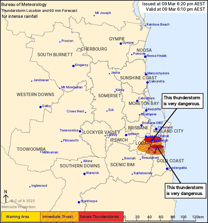
IMAGE: BOM
6.00 PM | EMERGENCY WARNING issued for major flooding
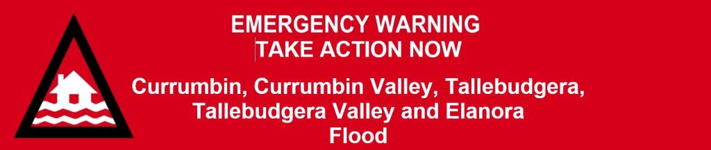
People in Currumbin, Currumbin Valley, Tallebudgera, Tallebudgera Valley and Elanora should TAKE ACTION NOW due to MAJOR flooding. Roads are now likely to be flooded. If you are near floodwater, you may need to get up as high as you can to survive.
Follow your emergency plan if you are in danger. If you do not have a plan, it may be too late to leave safely.
IF IT’S FLOODED FORGET IT. Never drive, walk or ride through floodwater. This is the main cause of death and injury during flooding.
Major flooding is happening now. There may be multiple warnings for this area. To see all current warnings, visit City of Gold Coast Disaster Dashboard. Stay up to date because conditions could change quickly.
If your life is in danger, call Triple Zero (000) immediately.
What are we expecting?
- Floodwater can be unpredictable, very deep, rise quickly and move fast.
- Homes and buildings will be flooded in some places.
- Roads or bridges may be cut off by flood water, and you may be isolated until flood waters recede.
- Trees and powerlines may have fallen in some places.
- Landslides could happen – be aware of fallen earth, rocks, debris or trees.
- Power, phones, internet, and water might stop working.
- It may not be possible for emergency services to rescue you.
What you need to do:
Stay up to date because conditions could change quickly:
- Visit the Gold Coast Disaster and Emergency Dashboard for warnings and view the map to consider your proximity to the potential flood area.
If you are near floodwater:
- Go to a safe place indoors and up as high as you safely can. Do not enter areas you cannot exit if the water keeps rising (for example, roof spaces).
- If you cannot shelter inside, get to higher ground away from trees. Trees can fall down when the ground is very wet.
- If your life is in danger, call Triple Zero (000) immediately.
- Move away from creeks and rivers.
- Help other people who are with you if you can.
- Tell someone where you are.
- Do not wait for instructions. Be aware of what is happening around you, as you could find yourself suddenly in danger. Act now if there is danger.
If you are already driving:
- Pull over in a high, safe place away from creeks, rivers and trees. Driving is dangerous now.
- Do not drive through floodwaters.
4.30 PM | Watch and Act Alert issued for Gold Coast

Council has issued a Watch and Act alert for the Gold Coast as rain continues to fall, bringing the threat of flooding.
There is also the threat of thunderstorms across the city with residents urged to closely monitor conditions.
“The City of Gold Coast advises people to PREPARE NOW for moderate to major flooding across the Gold Coast.
City of Gold Coast advises MODERATE to MAJOR flooding could occur.
Follow your emergency plan. If you do not have a plan, or intend to leave, don’t wait. Take shelter now. ”
For emergency help in floods and storms, call the QLD SES on 132 500 or download the SES Assistance QLD App. In life threatening situations, call Triple Zero (000) immediately.
What are we expecting?
- Water levels are rising.
- Flooding above floor level is possible in some buildings.
- Roads and bridges could become flooded, do not drive through or enter floodwater.
- Additional flash flooding can occur anywhere, anytime from heavy rainfall. There may not be enough time to warn you about flash flooding or closed roads.
- Bridges, homes and low lying roads may be impacted by floodwater.
- You may be isolated until flood waters recede.
- Powerlines and trees have fallen. They can be hard to see when covered in debris.
- The power and phone services could be out for a long time. They will be restored when staff and supplies can get through, and when safe.
What you need to do:
- If it’s flooded, forget it. Stay out of flood water.
- If you have children make sure they are with you or an adult you trust.
- Warn family, friends, and neighbours in the area. Help others if you can.
4.00PM | Work continues to restore phone services.
Telstra has provided an update on phone and internet services across southeast Queensland and northern New South Wales impacted by TC Alfred.
There are 164 mobile sites disrupted, 7,268 landline services disrupted and 1,849 ADSL services impacted.
Here’s a statement from Telstra:
We’re continuing to make progress bringing customers affected by ex-Tropical Cyclone Alfred back online.
The widespread power outages due to the severe weather are affecting some mobile and landline services in parts of south east Queensland and northern New South Wales.
Our teams on the ground are working closely with authorities, including the Australian Defence Force, to ensure we can get in and restore affected services.
A number are back online already, but there’s still a big job ahead and we’re working to get everyone up and running ASAP when it’s safe to do so.
Our network sites have backup systems that keep services running for as long as possible, but customers should be prepared for disruptions if power’s out for a long time in their area, or if access is cut to a site.
We’ve also activated our assistance package for affected customers, which includes extra mobile data and free call diversions.
We know this is a tough time and we urge everyone to stay safe and thank them for their patience.
2:00 PM | Latest update on schools, transport
The Premier has confirmed Gold Coast school will remain closed on Monday.
Some schools across other parts of southeast Queensland will start to reopen, but not here.
“Where its safe to do so, schools will reopen with the exception of the Gold Coast where there remains some significant damage, power loss and issues with transport,” David Crisafulli told reporters on Sunday.
Bus and tram services across the Gold Coast will also remain suspended tomorrow.
Some rail services across the southeast will resume to a Sunday timetable but the Gold Coast line will remain closed.
*An earlier version of this update said all rail services would resume Monday based on the Premier’s advice. Queensland Rail has since clarified the Gold Coast line will remain closed.
11.30AM | Parts of the Gold Coast have experienced some extraordinary rainfall totals. Here are some of the biggest falls recorded in the last four days to 9am Sunday.
Upper Springbrook – 809 mm
Lower Springbrook – 769mm
Springbrook National Park – 716mm
O’Reilly’s – 586mm
Upper Tallebud – 509mm
Mt Tamborine – 406mm
Bonogin – 589mm
Tallebudgera Ck Dam 578 mm
Currumbin Ck – 453mm
Mudgeeraba – 411mm
Palm Beach – 397mm
Coombabah – 372mm
10:46AM | Watch and Act issued for Currumbin Valley
In life threatening situations, call Triple Zero (000) immediately. For non-life-threatening flood and storm emergency assistance call the SES on 132 500 or download the SES Assistance QLD App.
What are we expecting?
- Currumbin Creek water levels are rising, and the area of flooding will be bigger, and the floodwater will be deeper.
- Flooding above floor level is possible in some buildings.
- The following roads may be cut off by flood water, and you may be isolated until flood waters recede:
- Currumbin Creek Road near Kianga Court
- Currumbin Creek Road near Ridgetop View Park
- Currumbin Creek Road near Currumbin Creek Roadside Reserve
- Other roads and bridges could become flooded, do not drive through or enter floodwater.
- Additional flash flooding can occur anywhere, anytime from heavy rainfall. There may not be enough time to warn you about flash flooding or close roads.
- Landslides could happen – be aware of fallen earth, rocks, debris or trees.
- If you remain in the area, you may become isolated without power, water, communications, sewerage and other essential services.
- It may not be possible for emergency services to rescue you.
What you need to do:
- If you have an emergency plan, follow it now.
- Prepare now so you can get out of danger safely and quickly if the flooding gets worse.
- Decide where you and the people you live with will go and how you will get there. Find a safe and high place away from flooding. This could be out of the area or higher ground where you are.
- Advise your family, friends, or neighbours of your location.
- Do not wait for official warnings. Be aware of what is happening around you, as you could find yourself suddenly in danger. Act now if there is danger.
- Stay up to date because conditions could change quickly:
- Visit the Gold Coast Disaster and Emergency Dashboard for warnings and view the map to consider your proximity to the potential flood area (dashboard.cityofgoldcoast.com.au).
- Monitor the river height on the BOM website.
- Listen to your local radio station (91.7FM ABC Gold Coast).
- If it’s flooded, forget it. Stay out of flood water.
- If you find it hard to move quickly leaving early is safer than waiting. Call your support service, a family member, or a friend to help.
- Do not allow children near floodwater or storm drains. Make sure your children are with you or a responsible adult.
- Find out how to get ready for a flood and pack an emergency kit at Get Ready Queensland website.
- Be prepared to have no power. Charge mobile phones and other electronic devices now.
- Warn friends, family, and neighbours in the area. Help others if you can.
10:36 AM | Gold Coast Tips remain closed today
Find out more info here
9:30 AM| Major shopping centres starting to re-open
Confirmed Open (supermarkets and select retailers):
- Pacific Fair
- Robina Town Centre
- Australia Fair
- The Pines
- Paradise Centre
- Pimpama City
- Tweed City (partial reopening)
- The Oasis Broadbeach
- Capri on via Roma
- Ashmore City
- Q Store Mermaid
9.15AM | “It’s all guns blazing”: Energex crews re-commence work on the Gold Coast
Great news for thousands of Gold Coasters who remain without power this morning, with Energex crews given the green light to re-commence work.
Around 120,000 properties are still in the dark at the time of writing, but about 20,000 properties were restored of power overnight.
Energex crews worked yesterday afternoon and throughout the night but had to stop when conditions became too dangerous this morning.
Danny Donald from Energex says work has kicked back off again.
“The rain is certainly tumbling down on the Gold Coast but it hasn’t dampened the spirits of the crews who are out there just as it would be on a sunny day,” Mr Donald says
“It’s going to be a long day in this rain and wind but we’re monitoring conditions by the minute to make sure it’s still safe to be out. The rain is fine it’s just the wind’s we’ve got to watch.”
Crews may have to be recalled if winds get too windy, particularly those that operate bucket trucks in the air but at this stage it’s all guns blazing
8.45AM | Clean-up efforts begin for Gold Coast City Council crews
We’ll start to see plenty of boots on the ground as City crews work with state and federal agencies to begin the mammoth clean-up.
The City will assess damage to trees and infrastructure and crews are continuing to respond to priority incidents when safe to do so.
Since Wednesday at 3pm there have been more than 450 incidents reported to the City.
Council says residents and visitors are urged to ensure they are staying up to date with the latest news.
“The Gold Coast is expecting strong winds with significant gusts and possible heavy rain today,” a council statement states.
“For everyone’s safety keep an eye out for hazards, drive to conditions and stay alert to current warnings,
“There is the potential for more flooding as localised rainfall continues across the Gold Coast.”
Meantime, the SES has also hit the ground running right across the Gold Coast.
Nearly 1700 request for assistance have been made to SES with 621 resolved since the start of the event.
The City has transitioned its Evacuation Centres to Relief Centres from 8am today. They will be open until 5pm.
Relief Centres can be used for charging of medical equipment and essential communications:
- Runaway Bay Indoor Stadium, Sports Drive, Runaway Bay
- Burleigh Waters Community Centre, 111 Christine Ave, Burleigh Waters
- Pimpama Sports Hub, 139 Rifle Range Road, Pimpama
- Nerang Bicentennial Community Centre, 833 Southport Nerang Road, Nerang
The following City facilities remain closed today, until at least Monday 10 March:
- Parks and playgrounds
- Sporting venues not being used as evacuation centres
- All aquatic centres
- All libraries
- Community centres that are not being used for evacuation centres
- All customer service centres
- Waste and Recycling Centres and landfills
Council is urging everyone to stay up to date by visiting the City’s Disaster and Emergency Dashboard at: dashboard.cityofgoldcoast.com.au
7.00AM | Power beginning to be restored at thousands of Gold Coast homes
Power has been restored at thousands of homes across the Gold Coast, but more than 112,000 properties do still remain in the dark.
At the time of writing, it’s tools down for Energex crews as the weather conditions are too dangerous.
However, workers were able to get out and begin the mammoth restoration efforts yesterday afternoon and even through the night.
Over 20-thousand properties have had their power restored across the Gold Coast since yesterday.
Danny Donald from Energex has told myGC crews will get back out as soon as it’s safe to do so.
“Our crews did work last night doing a lot of assessing of the damage and some of the new damage that has been caused,” Mr Donald says.
“But they’ve got everything ready for our crews to start hitting the road this morning once this weather moves across and allows us to start safely hitting the road.”
6.30AM | Heavy rain lashing the Gold Coast, damaging winds pick up
The Gold Coast is being smashed by heavy rainfall as ex-Tropical Cyclone Alfred moves inland.
There’s been huge rainfall totals recorded across the city since 9am yesterday including over 240mm in Upper Springbrook and 207mm in Lower Springbrook.
Hinze Dam has recorded 205mm, while there’s been over 192mm of rainfall in Bonogin, 145mm in Mudgeeraba, 149 in Tallebudgera and 105mm in Burleigh Waters.
The Bureau of Meteorology is warning that heavy to locally intense rainfall is continuing today.
Major Flooding is occuring in the Tweed River, while a Generalised Flood Warning remains in place for the Nerang and Coomera Rivers.
The Gold Coast is also still experiencing some damaging wind gusts this morning of over 70km/hr at the Seaway.
BOM says damaging wind gusts are forecast to ease later this morning.
5.30 PM | Latest update from City of Gold Coast
City of Gold Coast downgraded its warning to advice level this afternoon however they urge residents to continue to stay informed.
Although conditions have improved, localised heavy rainfall and strong winds are expected to continue over the weekend.
For your safety, keep an eye out for hazards, drive to conditions and stay alert to current warnings.
There are trees and powerlines down and many traffic signals not operational which can cause danger on the roads.
Everyone is reminded to stay out of floodwaters. If it’s flooded forget it.
City crews have been assessing damage today and have been responding to priority incidents when it is safe to do so. They will continue responding to jobs tomorrow.
The City asks anyone to report damage to trees, roads or sewerage and water infrastructure via Report a problem or the City of Gold Coast App.
More than 1600 requests for assistance made to SES and 461 have been resolved since the start of the event.
SES crews have been responding to priority incidents today and will return tomorrow morning.
There are widespread power outages across the Gold Coast with more than 140,000 households impacted currently.
Be prepared for prolonged power outages.
If you see a fallen powerline, report it immediately by calling Energex. Do not touch a fallen powerline directly or with another object.
The City will be transitioning its Evacuation Centres to Relief Centres from 8am tomorrow (Sunday 9 March), open until 5pm.
Relief Centres can be used for charging of medical equipment and essential communications.
-
- Runaway Bay Indoor Stadium, Sports Drive, Runaway Bay
- Burleigh Waters Community Centre, 111 Christine Ave, Burleigh Waters
- Pimpama Sports Hub, 139 Rifle Range Road, Pimpama
- Nerang Bicentennial Community Centre, 833 Southport Nerang Road, Nerang
Queensland Health has advised that if power loss results in a medical emergency, go to a nearby hospital immediately to receive care.
If it is not a medical emergency, and you just need power to charge your medical device, use all other options first. The hospital should be the last option for this circumstance.
Hazardous surf conditions are still impacted the coast and it is important that everyone continues to stay away from the beaches and waterways.
The following City facilities are closed until at least Monday 10 March:
- Parks and playgrounds
- Sporting venues not being used as evacuation centres
- All aquatic centres
- All libraries
- Community centres that are not being used for evacuation centres
- All customer service centres
- Waste and Recycling Centres and landfills
3.50 PM | Gold Coast Airport to reopen
Gold Coast Airport will reopen to the public from 6am on Sunday 9 March following a three-day closure.
Safety inspections and operational checks have been carried out across the day and the aerodrome will open this afternoon ready for scheduled services to resume tomorrow.
Queensland Airports Limited Chief Operating Officer Marion Charlton thanked her team and the wider airport community for responding quickly to get the airport ready for reopening as soon as weather conditions allowed.
“As soon as it was safe, our teams returned to inspect the aerodrome, apron, and airport precinct to ensure we can safely resume operations once weather conditions improve tomorrow,” Ms Charlton said.
“With the region now entering the recovery phase, it is essential for us to reopen as quickly as possible, not only for passengers but also to provide critical access for emergency services and support agencies, including the Australian Defence Force.
“There will likely be some disruptions to scheduled services, so we encourage passengers to continue to monitor the status of their flight via their airline before heading to the airport. For anyone driving to and from the airport, please be careful on the roads.
“We appreciate the patience of our passengers and airline partners and look forward to reopening to the travelling public tomorrow.”
Brisbane Airport is also looking to resume services tomorrow.
3.00 PM | Warnings officially downgraded again
City of Gold Coast has revised down its current warning for the Gold Coast from Watch and Act to Advice level.
Residents are being advised to continue to stay informed of weather conditions including flooding on the Gold Coast.
Ex-Tropical Cyclone Alfred could still bring heavy rainfall.
Keep an eye out for hazards, drive to conditions and stay alert to current warnings.
2.15 PM | Warnings to reduce again
The local Disaster Coordinator says the warnings for the Gold Coast will be scaled back, with the weather for the rest of Saturday not looking as bad as first thought.
In a 2pm update, Mark Ryan said the warning level would likely be reduce back to the yellow level advice, meaning residents can use their own judgement and act with caution.
Mr Ryan said it was a “very busy night” but there were no injuries or loss of life, which he attributed that to people listening to the advice.
“Thank you for heeding our warnings and thank you for being on that journey,” he said.
“This has been a very unpredictable system and we’ve tried to keep those warnings up to date.”
However, hinterland communities are still being told to stay alert, particulary around Currumbin and Vallebudgera following overnight emergency warnings.
“Those warnings have now been removed off the system, so they’re back within normal limits of those gauges,” Mr Ryan said.
“But, it might be that as we see that rain this afternoon, those specific warnings come back up.”
2.00 PM | Council looking to open centres and libraries to help residents without power
Acting Mayor Donna Gates has confirmed work is underway to open up some community centres and libraries across the city to help those without power.
“To allow community to visit, get a cup of tea or coffee and charge their devices and any individual medical equipment that they may have,” Ms Gates says.
“The information about that, once it’s organised, will immediately go up on the city dashboard.”
https://dashboard.cityofgoldcoast.com.au
8.00 AM | Latest update from City of Gold Coast:
City of Gold Coast is warning residents the weather conditions remain dangerous, and residents are being urged to stay indoors.
Gold Coasters are being urged to remain indoors and monitor conditions after widespread flooding and significant damage across the city due to Tropical Cyclone Alfred.
Residents and visitors are urged to stay indoors as conditions are still dangerous with heavy rains and winds expected to continue.
More heavy rain resulting in flooding is expected today.
Everyone is reminded to stay out of floodwaters. If it’s flooded forget it.
Widespread flooding hit the Gold Coast last night with both the Currumbin and Tallebudgera creek catchments significantly impacted.
There is the potential for more flooding as heavy rains continue. Be aware of what is happening around you.
If it is not safe to leave, get up as high as you safely can where you are.
Residents and visitors are urged to avoid the road unless essential. Take care and drive to the conditions.
There are more than 80 road closures current due to fallen trees and localised flooding and this number will increase in coming days.
The City asks anyone to report damage to trees, roads or sewerage and water infrastructure via Report a problem or the City of Gold Coast App.
If you see a fallen powerline, report it immediately by calling Energex. Do not touch a fallen powerline directly or with another object.
If your own home is not suitable, sheltering with family or friends is always the best option if possible.
The City has three evacuation centres as a last resort.
- Runaway Bay Indoor Stadium, Sports Drive, Runaway Bay
- Burleigh Waters Community Centre, 111 Christine Ave, Burleigh Waters
- Pimpama Sports Hub, 139 Rifle Range Road, Pimpama
Anyone attending an evacuation centre should ensure they have basic toiletries, medication, personal identification and other documents, a change of clothes, sleeping bag or blanket, water bottle, towel, snacks and light meals, games and toys for their kids, and charges and power banks.
Please be aware that electricity and Wi-Fi access may not be available at the evacuation centres.
You can bring your pets with you, but they will be kept in a separate location and cared for by Animal Management.
All beaches are closed. Stay away from the beach and waterways.
The City is experiencing hazardous surf conditions, with abnormally high tides and it dangerous to be on the beach.
The following City facilities are closed until at least Monday 10 March:
- Parks and playgrounds
- Sporting venues not being used as evacuation centres
- All aquatic centres
- All libraries
- Community centres that are not being used for evacuation centres
- All customer service centres
- Waste and Recycling Centres and landfills
7.00 AM | More emergency warnings downgraded for the Gold Coast
City of Gold Coast has confirmed the earlier emergency warning for the Gold Coast has been downgraded to a Watch and Act.
The City of Gold Coast advises people to continue to monitor conditions for flooding across the Gold Coast. Destructive winds from Ex-Tropical Cyclone Alfred are easing, however dangerous flooding continues across the southern Gold Coast and thunderstorms are forecast.
The emergency warning for Tallebudgera Creek has also been downgraded from Too Dangerous to Leave to a Watch and Act.
City of Gold Coast advises people to monitor conditions for flooding in Tallebudgera. Destructive winds from Ex-Tropical Cyclone Alfred are easing, however flooding may occur across the weekend.
6.30 AM | Energex already looking at where it can get on the ground today
Energex will start to look at what services it can restore today but some Gold Coast residents have been warned it could be days before power is back.
More than 119,000 properties around the city are currently without power and Paul Jordan from Energy Queensland said they were working to get that back up.
“We expect we will probably have in excess of 1000 wires down,” he told The Today Show on Saturday morning.
“Overnight, we got some customers back where it was safe to do so.
“We will start, when it’s safe to do so, getting people out on to the field and assessing that damage and making it safe.”
239 generators have been placed around the islands, southeast and depots in the lead-up to the weather event which crews are expected to utilise over the coming days.
“The approach is quite structured. We have a lot of wires down so the first thing that we’ll be doing is making sure that our assets and our system is safe,” Mr Jordan said.
“So, that might mean we isolate more assets and services.
“Then we’ll concurrently be assessing the damage and we do that both on the ground and, when its safe, in the air.
“Then we’ll be looking at our restoration but we’ll be restoring throughout that where it’s safe to do so.”
He admitted the ongoing heavy rainfall and flooding would be a concern.
“With so many customers off it’s likely to be more than a week for some customers,” he said.
6.15 AM | Cyclone Alfred has now been downgraded to a Tropical Low
The Bureau of Meteorology has confirmed Alfred has now weekend to a Tropical Low.
The system lies just off Bribie Island and is slow moving to the west-northwest, it is expected to make landfall along the coastline between Maroochydore and Bribie Island this morning before moving inland and weakening later today. Bands of heavy rainfall have been occurring over the southeast coast, with damaging wind gusts affecting coastal and island communities.
A Severe Weather Warning remains in place for the southeast.
“Heavy rainfall which may lead to flash flooding is developing across the Moreton Bay islands, Gold Coast and Scenic Rim this morning,” the warning states.
“Heavy rainfall is then forecast to become more widespread over the warning area later today and on Sunday as the system moves inland, including Brisbane, Ipswich, the Sunshine Coast and Gympie. Six-hourly rainfall totals between 100 and 130 mm are likely today and into Sunday morning, with isolated six-hourly totals between 170 mm and 200 mm about higher terrain. 24-hourly totals between 200 and 250 mm are likely.
“Locally intense rainfall which may lead to dangerous and life-threatening flash flooding may develop later today and on Sunday near and south of the system centre, and in bands of showers and thunderstorms wrapping around the system over the Southeast Coast and southern Wide Bay and Burnett. Six-hourly rainfall totals between 200 and 250 mm and 24-hourly totals between 350 and 450 mm are possible. All rainfall numbers are dependent on the movement and position of the system.
“Damaging wind gusts with peak gusts around 100 km/h are possible today with showers and thunderstorms across the southeast Queensland coast, elevated terrain, and the remainder of the warning area.”
6.00 AM | Emergency flood alert in Currumbin downgraded
City of Gold Coast has downgraded its emergency warning for Currumbin Creek to a Watch and Act.
City of Gold Coast advises people to monitor conditions for flooding in the Currumbin Catchment. Destructive winds from Tropical Cyclone Alfred are easing, however flooding may occur across the weekend.
5.00 AM | Roof blown off apartment complex in Labrador
Tropical Cyclone’s Alfred’s destructive winds have ripped the roof off of a block of units in Labrador.
Police evacuated 15 people from the apartment complex on Frank Street at around 10.15pm.
One woman suffered minor injuries and was taken to the Gold Coast University Hospital.
The others were taken to the Burleigh Heads Evacuation Centre.
3.00 AM | Winds ease but rains continue to lash the Gold Coast
Damaging winds have eased significantly across the Gold Coast this morning amid Tropical Cyclone Alfred, now sitting at around 60km/hr.
Wind gusts of up to 107km/h were recorded at the Seaway last night, and around 80km/h at Coolangatta.
The rainfall has settled and is expected to stick around throughout Saturday and Sunday.
Heavy rainfall bands are continuing to move over southeast Queensland and northern NSW, brining locally intense rainfall which may lead to life-threatening flash-flooding.
We’ve already seen huge rainfall totals since 9am yesterday, including 195mm in Lower Springbrook, 188mm in Tallai, 145mm in Bonogin and 120mm in Currumbin Creek.
Emergency Warnings remain in place for Currumbin and Tallebudgera, with residents advised it is too dangerous to leave, and to move to higher ground.
Parts of the Northern Rivers are being told to stay indoors due to impacts from Tropical Cyclone Alfred unless they’ve been directed to evacuate.
The order includes: Tweed Heads, Murwillumbah, Kingscliff, Lismore, Coraki.
Full list on the HazardWatch site.
Meantime, there’s now more than 119,000 properties across the city without power.
Energex crews will work on getting power restored once conditions ease and it’s safe enough to do so.
Emergency response teams will be able to get a better look at the damage at first light.
There are dozens of reports of trees and powerlines down right across the Gold Coast.
2.00 AM | EMERGENCY WARNING issued for Tallebudgera

City of Gold Coast advises people in Tallebudgera there is dangerous, wide-spread, fast-moving and unpredictable flooding occurring near Tallebudgera Creek. Stay in place, it is TOO DANGEROUS TO LEAVE.
Get up as high as you can where you are. Evacuation routes are now cut off by flooding.
If your life is in danger, call Triple Zero (000) immediately.
Emergency services may not be able get to you because it is too dangerous.
What are we expecting?
- Homes and buildings will be flooded.
- Main roads are closed.
- Evacuation routes are closed.
- Power, phones, internet, and water might stop working.
What you need to do:
- Stay where you are and get up as high as you safely can where you are. This could be upstairs or on the roof if it is safe to do so.
- If it’s flooded, forget it. Stay out of flood water.
- If you have children make sure they are with you or an adult you trust.
- Help other people who are with you if you can.
- Stay in place until you are rescued, or the water goes down enough to safely leave.
10:00 PM | Emergency Warning Currumbin Creek

City of Gold Coast advises people in the Currumbin Catchment there is dangerous, wide-spread, fast-moving and unpredictable flooding occurring near Currumbin Creek. Stay in place, it is TOO DANGEROUS TO LEAVE.
Get up as high as you can where you are. Evacuation routes are now cut off by flooding.
If your life is in danger, call Triple Zero (000) immediately.
Emergency services may not be able get to you because it is too dangerous.
What are we expecting?
• Homes and buildings will be flooded.
• Main roads are closed.
• Evacuation routes are closed.
• Power, phones, internet, and water might stop working.
What you need to do:
• Stay where you are and get up as high as you safely can. This could be upstairs or on the roof if it is safe to do so.
• If it’s flooded, forget it. Stay out of flood water.
• If you have children make sure they are with you or an adult you trust.
• Help other people who are with you if you can.
• Stay in place until you are rescued, or the water goes down enough to safely leave.
8.45 PM | Power outages continue to soar across the Gold Coast
Wild winds are continuing to wreak havoc across the city, with more than 73,000 homes now without power.
Close to 6,000 of those properties are in Labrador, 4000 are in Coombabah, 3500 are in Biggera Waters, while 4300 are in Runaway Bay.
Southern Gold Coast residents are also in darkness, with Coolangatta, Burleigh, Mermaid Beach, Miami, Molendinar and Palm Beach among the dozens of other suburbs impacted.
Paul Jordan from Energy Queensland says tonight’s power outages are just the start of what’s to come as Tropical Cyclone Alfred edges closer to making landfall.
“We envisage losing tens of thousands more customers and that will be right across from the Gold Coast, Brisbane to the Sunny Coast,” Jordan said.
More information on current power outages can be found here.
8.15 PM | Boil water alert issued for Bilambil Heights in the Tweed
Residents of Bilambil Heights are being urged to boil their tap water for drinking purposes until further notice after Tweed Shire Council issued a boil water alert for the suburb.
“Due to asset damage at Bilambil Heights associated with the Tropical Cyclone Alfred event, Council cannot guarantee the quality of the water in the suburb,” Council said.
“Water used for drinking or food preparation should be brought to a rolling boil to make it safe. Kettles with automatic shut off switches can do this if you have power supply. Water should then be allowed to cool and stored in a clean container with a lid and refrigerated.
“If you cannot boil the water due to a power outage, unscented household bleach (containing 4% – 5% available chlorine) may be used. Add 2 drops of bleach to 1 litre of water (or 4 drops if the water is cloudy), mix well, and allow to stand for 30 minutes before use.”
This advice should be followed until further notice.
Tap water in all other parts of the Tweed is unaffected and remains safe.
8.00 PM | Tropical Cyclone Alfred less than 100 kilometres from the Gold Coast
We’ve just received the latest update from the Bureau of Meteorology which is saying Tropical Cyclone Alfred is now just 85 kilometres east of Brisbane and 70 kilometres northeast of Gold Coast.
It’s still a Category Two system with sustained winds near the centre of 95 kilometres per hour and wind gusts to 130 kilometres per hour.
The system is continuing its slow pace towards the Southeast Queensland Coast, moving northwest at just 7 kilometres per hour.
Alfred is most likely to cross over the Moreton Bay Islands Saturday morning before crossing the mainland coast, most likely between Noosa and Beenleigh later during the day.
6.30 PM | Tropical Cyclone Alfred now starting to impact NBN services
The severe weather caused by Tropical Cyclone Alfred has started to impact nbn services across South East Queensland and Northern New South Wales.
There NBN network says there are currently around 30,000 services impacted across their fixed line and nbn Fixed Wireless technologies.
- South East Queensland: Arundel, Ashmore, Beaudesert, Benowa, Biggera Waters, Bilborough Lookout, Bilinga, Bonogin, Bundall, Burleigh Heads, Burleigh Waters, Capalaba, Coolangatta, Currumbin, Currumbin Waters, Elanora, Everton Park, Gold Coast-Tweed Heads, Greenbank, Highland Park, Labrador, Macleay Island, Mermaid Beach, Mermaid Waters, Merrimac, Miami, Molendinar, Mount Tamborine, Mudgeeraba, Mudgeeraba, New Farm, Oxenford, Palm Beach, Paradise Point, Robina, Rocklea, Russell-Macleay Islands, Southport, Stephens, Sunnybank, Surfers Paradise, Tallai, Tallebudgera, Tallebudgera Valley, The Falls, Toogoolawah, Tugun, Varsity Lakes, Victoria Point, Worongary.
- Northern New South Wales: Ballina, Bilambil Heights, Brooms Head, Bumble Hill, Burringbar West, Byron Bay, Chillingham, Chinderah, Clothiers Creek, Dunbible, Eltham, Eureka East, Glengarrie West, Hayters Hill, Kingscliff, Knockrow, Kulnura, Kulnura East, Kunghur, Mangrove Mountain, Mangrove Mountain South, Mullumbimby, Mullumbimby Creek, Murwillumbah, Murwillumbah Hill, Myocum, Newrybar, Possum Creek, Pottsville Beach, Rosebank, Springbrook, Terranora, Teven, Tuckombil, Tullera South, Tweed Heads, Tweed Heads South, Uki, Yamba, Zara.
Most of the impacts are related to power outages.
“Our team continues to support local authorities across the impacted area by mobilising field workforce and deploying temporary network infrastructure, as well as other assets such as generators, to maintain the operation of the nbn network wherever possible and safe,” the NBN said.
“The health, safety, and wellbeing of our people, partners, and customers remain our top priority”.
5:00 PM | The PM talks to Moyra and Big Trev
3.45 PM | Red Alert warning issued for the Gold Coast with residents told ‘TAKE SHELTER NOW’
Gold Coasters are being told to take shelter immediately with the city’s emergency warning upgraded to red alert status.
“City of Gold Coast advises people on the Gold Coast to take shelter now from Tropical Cyclone Alfred and stay indoors overnight,” the warning states.
“Expect stronger winds, heavier rain, flooding and a potential storm surge”.
We’re being told the rain will continue after the winds ease, which will cause flooding today and over the weekend.
“Take shelter in the strongest part of the building you are in,” the warning reads.
“This will be away from big windows. It could be a bathroom, walk-in wardrobe, or hallway.
“If you experience flooding, get up as high as you can where you are. This could be a kitchen bench or second story.”

What are we expecting?
The Bureau of Meteorology (BOM) advises Tropical Cyclone Alfred is moving slowly towards the southeast Queensland coast. BOM advises:
- DAMAGING WIND GUSTS of up to 120 kilometres per hour are occurring now.
- DESTRUCTIVE WIND GUSTS of up to 155 kilometres will develop from tonight and persist until early Saturday morning. These will start along coastal areas of the northern Gold Coast.
- HEAVY to locally INTENSE RAINFALL which may lead to DANGEROUS AND LIFE-THREATENING FLASH FLOODING is likely to develop from this afternoon. This will continue during the weekend.
- ABNORMALLY HIGH TIDES and DAMAING SURF could cause flooding particularly during tonight’s high tide.
You should expect:
- The wind is very dangerous and will be very loud.
- You may hear things breaking outside and hitting your house.
- Winds could stop suddenly if the eye of the tropical cyclone goes over. Very dangerous winds could start again quickly from a different direction.
- Very strong winds can knock down trees and powerlines, blow roofs off houses, and blow away anything not tied down outside. This is a risk to life.
- Heavy rain will continue after the winds ease and this will make the flooding worse.
- Power, phone, and internet will stop working. They could be out for a long time.
- There may be multiple warnings for your area due to the wind, heavy rain and flooding.
What you need to do:
- Cover any windows in your safe room with a mattress or heavy blankets. This could protect you if the window breaks. Keep all doors and windows closed.
- If the roof comes off, shelter under your mattress and blankets.
- Stay in your safe place. This could be for several hours.
- Watch for more flooding around you after the winds ease.
- Keep pets in a safe place inside.
- Do not use generators inside. Fumes can be deadly.
- Limit use of devices to save batteries. Listen to local radio for updates.
3.30 PM | Power outages now affecting Telstra network
“Power outages due to Tropical Cyclone Alfred are affecting some mobile and landline services, mainly in parts of the Gold Coast’s south and northern New South Wales,” Telstra Area General Manager May Boisen said.
“Our network sites have backup systems that are keeping many services running for as long as possible, but customers should be prepared for disruptions if power’s out for a long time in their area, or if access is cut to a site.
“We have teams on the ground ready to go and we’re working closely with authorities to ensure we can get in and bring affected services back online ASAP.
“We’ve also activated our assistance package for affected customers, which includes extra mobile data and free call diversions”.
2.45 PM | Weather conditions to deteriorate again this afternoon
City leaders have warned conditions across the Gold Coast will deteriorate this afternoon, with residents being told to stay home.
“From 4pm today, we would like to stress that everyone should stay home,” Acting Mayor Donna Gates said.
“The advice is that the event will significantly increase in intensity and it’s time to be safe at home”.
Disaster Coordinator Mark Ryan said the city’s emergency warning is likely to be upgraded from a Watch and Act alert to a Seek Shelter.
“In the next hour or so the Gold Coast will move towards an emergency warning, our red highest level warning,” he said.
“We are asking people to shelter now. It’s possible we are going to ask people to shelter for 24 to 36 hours.
“That’s because, particularly around coastal areas, we could see destructive gusts of over 155km/h before, during and after this system crosses to the north of us”.
11:54 AM | Premier David Crisafulli’s latest update
11.40 AM | Currumbin Valley flooding advice warning issued
Council has issued an alert to Currumbin Valley residents to monitor conditions for minor flooding.
The water level in Currumbin Creek at Currumbin Creek roadside reserve has reached 46.04m and is rising.
This is more than 1.3m above the usual river level.
City of Gold Coast advises moderate flooding could occur if there is a further rise of 0.3m, which could take less than an hour.
“You need to keep informed and decide what actions you will take if the water levels continue to rise,” the Council alert states.
“There may be multiple warnings for this area. To see all current warnings, visit The City of Gold Coast Disaster and Emergency Dashboard.”
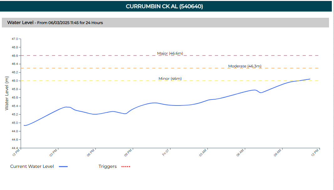
IMAGE: GCCC
9.30 AM | Couple injured after large gum tree smashes into Currumbin Valley home
A man and woman have been rushed to hospital after a massive gum tree crashed into their home, trapping them inside.
The tree came down on the property on Piggabeen Rd in Currumbin Valley just after 7.30am on Friday as wild winds from Cyclone Alfred continue to lash the city.
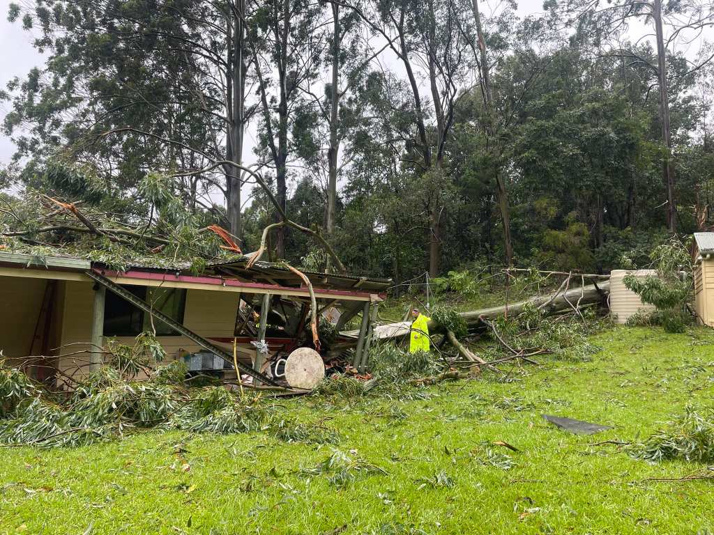
PHOTO: Queensland Ambulance
Photos from the scene show the level of destruction caused, with the house essentially split in half by the tree.
The man, aged in his 60s, suffered chest injuries, while the woman, aged in her 50s, sustained facial injuries.
Both were rescued by fire crews before being taken to the Gold Coast University Hospital in stable conditions.
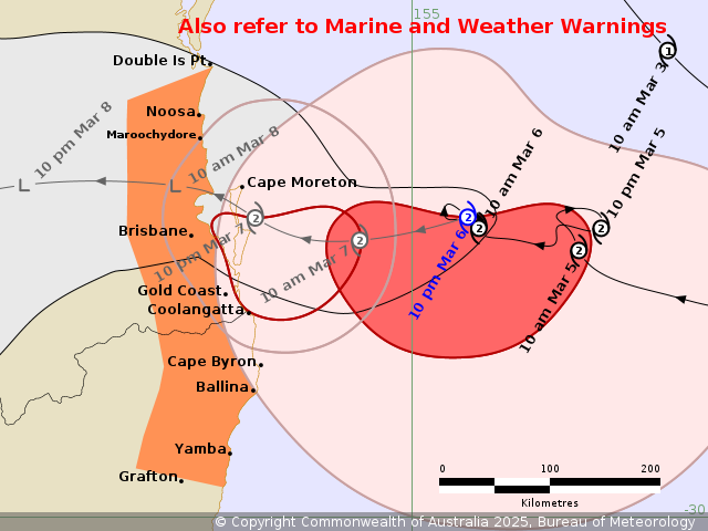
8.00 AM | Latest BOM Cyclone Advice Bulletin
Tropical Cyclone Alfred is continuing its crawl towards Queensland and is now just 140km east northeast of the Gold Coast.
Alfred remains a category two system and is moving at just 6km/h with BOM still forecasting landfall on Saturday morning.
The latest tracking map shows Alfred crossing the coast around the Moreton Bay area, possibly only as a category one system.
Parts of the southeast Queensland coast, including the Gold Coast, as well as northern parts of New South Wales are expected to start experiencing wind gusts up to 120km/h from later today, with the Bureau still warning of wind gusts of 155km/h as Alfred makes landfall.
Rainfall is also expected to start intensifying which could lead to ‘dangerous and life-threatening flash flooding’.
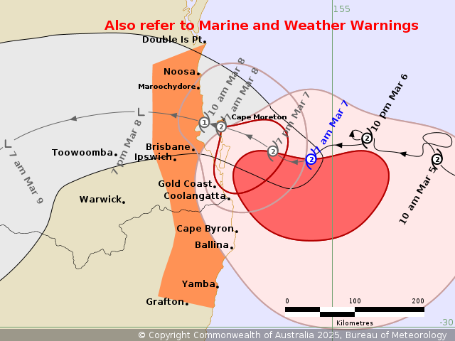
IMAGE: BOM
6.15 AM | Thousands of homes without power, likely to be offline for days
The number of homes and businesses across the Gold Coast that have lost power continues to climb.
According to Energex, there are 24,582 customers currently offline, spread right across the city, with that number expected to rise significantly the closer Alfred gets,
Some of the worst impacted suburbs include Biggera Waters, Bilinga, Bonogin, Burleigh Heads, Burleigh Waters, Coolangatta, Currumbin Valley, Mermaid Beach, Mudgereeba and Reedy Creek.
Energex is also warning that it could be some time before power is restored due to the conditions.
“There’s a good potential that the homes that currently do not have power and the ones that will lose power throughout the day won’t be restored until the storm passes, simply because it’s just becoming too dangerous for our crews to get out there,” Energex spokesperson Danny Donald told Hot Tomato.
“It’s too windy to get our cherry pickers up in the air because they’ll blow over and the last thing anyone wants…is people injured as a result of this cyclone.”
For the latest outages head to the Energex website
6.00 AM | Tropical Cyclone Alfred continues his erratic path towards Queensland as millions of people brace for his impact.
The system did another U-turn overnight but is now back on track, albeit very slowly.
Alfred is still a category two system and estimated to be around 180ks east northeast of the Gold Coast.
The BOM is forecasting it to cross the coast around the Moreton Bay region, likely on Saturday morning and could weaken to a category one system just before it does.
Damaging wind gusts of 120km/h are expected as Alfred continues his approach on Friday, increasing to 155km/h just before the system makes landfall.
A band of heavy showers has been impacting parts of the Gold Coast and northern New South Wales with the rain set to intensify throughout the day.
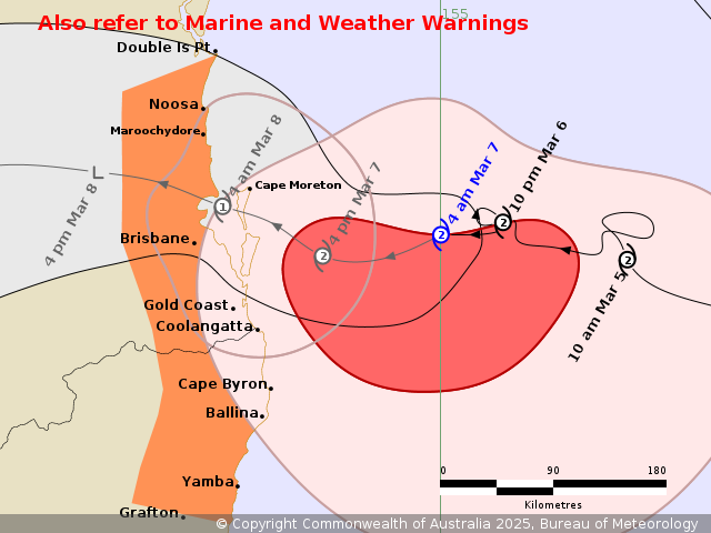
IMAGE: BOM
2.00 AM | Latest BOM cyclone bulletin
Tropical Cyclone Alfred continues to edge closer towards the coast as millions of people bunker down.
Alfred remains a category 2 system and is estimated to be 185km east northeast of the Gold Coast and 205km east of Brisbane.
But the system is moving slowly, which will likely prolong the intense rainfall heading our way.
The Gold Coast has already started feeling the early impacts of Alfred with rain settling in and winds picking up across the city.
Wind gusts of 87km/h have already been recorded at Coolangatta overnight while the Seaway has recorded gusts of 85km/h.
BOM is forecasting those wind gusts to hit speeds of 120km/h on Friday morning, increasing to 155km/h as Alfred makes landfall, before easing later on Saturday.
IMAGE; BOM
12:10AM | Widespread power outages hitting the Gold Coast already
More than 16,000 homes and businesses across the Gold Coast are already without power in a sign of things to come.
The majority of impacted customers are on the southern Gold Coast in suburbs including Coolangatta, Bilinga, Burleigh Heads, Currumbin and Tugun.
Areas of the Hinterland are also heavily impacted including Tallebudgera Valley, Currumbin Valley and Mudgeeraba.
Energex has warned it could be some time before conditions are safe enough for crews to get out and restore power to affected customers.
Latest info on power outages from Energex here
5:00pm | Meteorologist Tony Auden weighs in on TC Alfred’s erratic behaviour
4:50PM | Assistant Fire Commissioner Mark Stuart
Moyra and Big Trev caught up with Mark Stuart, the Assistant Fire Commissioner about the plans in place to help out Gold Coasters should they need it over coming days.
4.30 PM | Watch and Act Alert upgraded for Gold Coast residents
Council has now upgraded its Watch and Act Alert, urging people on the Gold Coast to “prepare to take shelter” tonight.
“Tropical Cyclone Alfred is moving slowly towards the Queensland coast and weather is getting worse,” the alert states.
We’re being warned to expect destructive winds and significant flooding.
“Check the Disaster Flood Risk Map. If you are in a risk area, decide now where you will take shelter,” Council said.
“A storm surge will occur tonight. It may exceed the highest tide of the year by over a metre.
“Everyone should take shelter at home or in a safer place”.
4.00 PM | Emergency warnings issued for parts of northern NSW
Residents in Fingal Head are now being told to evacuate before 9pm tonight due to “forecast cyclone related major flooding”.
That includes all properties along Fingal Road, Lagoon Road and between Queen Street and Main Street.
“You must evacuate before this time because forecasted heavy rain fall will close evacuation routes,” NSW SES said.
Those in Tumbulgum, Stotts Island and surrounds are also being directed to evacuate, as well as residents in Lismore.
⚠️Emergency Warnings – Evacuate before 9:00pm Thu 06 March 2025 for locations:
🔺Uki
🔺Fingal Heads
🔺Tumbulgum
🔺North Lismore
🔺South Lismore
🔺Lismore CBD
🔺East Lismore
🔺Billinudgel
🔺Low lying parts of Kyogle
🔺Bungawalbin
🔺Low lying areas of Coraki pic.twitter.com/mr3XUymJCt— NSW SES (@NSWSES) March 6, 2025
Further information on the latest evacuation orders can be found here.
3.30 PM | Additional evacuation centre opens for northern Gold Coast residents
Anyone needing to leave their homes and can’t stay with family or friends can now take refuge at the Pimpama Sports Hub on Rifle Range Road.
Centres at Burleigh Waters and Runaway Bay are also open, however the Nerang Bicentennial Community Centre is now closed.
Gold Coast evacuation centre locations:
- Pimpama Sports Hub (139 Rifle Range Rd, Pimpama)
- Runaway Bay Indoor Stadium (Sports Drive, Runaway Bay)
- Burleigh Waters Community Centre (111 Christine Avenue, Burleigh Waters)
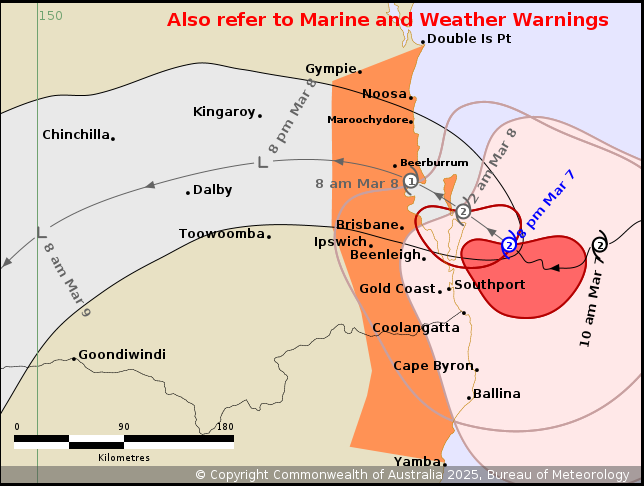
3.00 PM | Latest Cyclone Alfred tracking map
The Premier says Tropical Cyclone Alfred is starting to pack a punch as it continues its slow journey towards the South East Queensland coast.
According to the Bureau of Meteorology’s latest tracking, the system is due to cross the coast in the early hours of Saturday.
It currently remains a Category Two as it sits around 230 kilometres east northeast of Gold Coast with winds of 95km/h and gusts of up to 130km/h.
“The centre of Alfred is expected to cross the coast very early Saturday morning, most likely between Noosa and Coolangatta,” BOM said.
While still at least a day away from making landfall, the system is already starting to make its presence felt with damaging winds, heavy rain and huge swell.
“There was a wind gust which was recorded of 96 km/h at Cape Moreton a little while ago and the Gold Coast Seaway a recording of 80 km/h,” David Crisafulli said.
“Those winds will continue to intensify, but what it shows you is that the system does continue to track towards the coast.
“Powerful waves have also been observed along the Queensland Coast, we’ve recorded waves of 12.3 metres off the Gold Coast”.
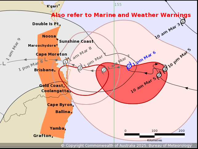
1.55 PM | RACQ roadside assistance services paused in SEQ
The State’s peak motoring body has confirmed it will be suspending all roadside assistance services from 7pm Thursday.
“For the safety of our Patrols and Tow Truck Operators, we will pause all RACQ roadside assistance services in South East Queensland and as far west as Withcott in the Lockyer Valley from 7pm today until further notice,” RACQ said in a statement.
“Please stay off the roads today and do not drive again until authorities advise it is safe.
“We will not be able to attend any callouts while Tropical Cyclone Alfred is impacting SEQ as it will be too dangerous for our operators”.
11.30 AM | Latest Cyclone Alfred tracking map
The Bureau of Meteorology is now estimating Tropical Cyclone Alfred will cross the South East Queensland coast very early Saturday morning.
As at 11am Thursday, Alfred was still a category 2 system 225 kilometres east northeast of Gold Coast with winds of 95km/h and gusts of up to 130km/h.
The system is now moving west at 10 km/h.
“Tropical Cyclone Alfred has been oscillating offshore of the southeast Queensland coast,” BOM said in its latest update.
“Alfred’s approach to the southeast Queensland coast has slowed.
“Alfred is currently category 2 and is expected to remain of similar intensity until the centre starts to interact with the coast and Islands.
“The centre of Alfred is expected to cross the coast very early Saturday morning, most likely between Noosa and Coolangatta”.
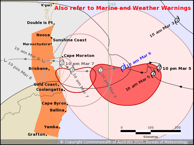
7:41 AM | Energex hoax warning
Energex is reporting hoax texts are circulating advising that they will be cutting power before Alfred makes landfall which is untrue.
7.00AM | Watch and Act alerts issued across parts of northern NSW
The New South Wales SES has issued a number of flood warnings across the Tweed with some residents urged to prepare to evacuate.
The Watch and Act alerts cover parts of Hastings Point, Fingal Head, Pottsville, Chinderah, Uki as well as the Kingscliff North Caravan Park, the Kingscliff Holiday Park and properties along Cudgen Creek.
Authorities are also warning people to stay away from Fingal Head beach with a warning issued for coastal erosion.
Latest NSW SES alerts: Homepage | NSW SES
6.30AM | Power outages impacting customers already
Hundreds of homes and businesses on the Gold Coast are already without power this morning in what could be a sign of things to come.
As at 6.30am, 715 customers were offline across the city.
The majority of those were in Springbrook with other customers in Bonogin, Currumbin Valley and Currumbin Waters also affected.
More than 1500 homes and businesses in the Tweed are also without power this morning.
Most of those are in Banora Point with Essential Energy reporting a tree has come down on wires.
There is also a handful in Tweed Heads who are currently offline.
6.00AM | Latest Cyclone advice from BOM
Tropical Cyclone Alfred continues its slow crawl towards the Queensland coast with uncertainty about when it will make landfall.
As at 5am Thursday, Alfred was still a category 2 system 300km east of the Gold Coast with winds of 95km/h and gusts of up to 130km/h.
The system is moving west southwest at just 7 km/h.
Alfred is now not forecast to cross the coast somewhere between Coolangatta and Maroochydore until late on Friday or early Saturday.
“We saw the system overnight do a loop on itself which is what delayed its run into the coast. Thats pretty rare but it can happen,” Premier David Crisafulli told Seven.
“In the end it gives people a little bit more of a window but it still remains a category two.”
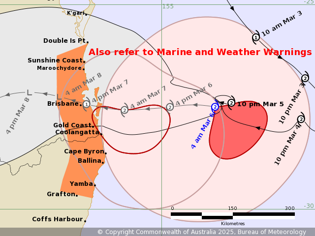
IMAGE: BOM
The delayed arrival of Alfred could mean even more rainfall for parts of southeast Queensland and northern New South Wales.
Rainfall totals of up to 800mm are still possible.
Wind gusts of up to 120km/h are expected to develop late on Thursday and continue into Friday.
Destructive gusts of up to 155 km/h could develop as Alfred gets closer to the coast on Friday.
9.00 PM | Cyclone Alfred to make landfall later than expected
Tropical Cyclone Alfred is now expected to cross the South East Queensland coast later than initially forecast.
Earlier Bureau of Meteorology modelling had the Category Two system making landfall around 2am on Friday, however that has now been updated.
According to the latest tracking map, Alfred is now estimated to cross the coast later on Friday, possibly even Saturday, after slowing down to a pace of just 7 kilometres per hour.

“The centre of Alfred is expected to cross the coast during Friday, noting that latest weather model data indicates the potential for a later crossing time than previously indicated,” BOM said.
“Location of crossing still remains most likely between Maroochydore and Coolangatta”.
4:00PM | Meteorologist Update
Tony Auden, 7 News Brisbane’s weatherman and meteorologist updates us with the latest tracking on the cyclone and what we should all be doing in preparation.
2.30PM | Major Gold Coast Shopping Centre to close
Pacific Fair has confirmed it will shut on Thursday and Friday.
The shopping centre’s carparks will also be closed off.
Supermarkets at Pacific Fair will remain open until 10pm Wednesday night.
2:10PM | Residents warned to be in place tonight ahead of “awful” conditions tomorrow
We’ve just had a fresh update from local authorities. Acting Mayor Donna Gates says the Gold Coast “remains the major area of concern” with residents urged to bunker down from tonight.
Tropical Cyclone Alfred is estimated to be 335 kilometres east of Brisbane and 310 kilometres east northeast of Gold Coast, moving west to northwest at 16km/h.
Alfred is still forecast to cross the coast north of Brisbane in the early hours of Friday morning with destructive wind gusts of up to 155km/h, a dangerous storm tide, and heavy rainfall that could lead to dangerous and life-threatening flash flooding.
“We’re still working and expecting the potential for 800mm of rain over two or three days, so it’s not good,” Councillor Gates told reporters.
The Acting Mayor warns conditions will start to worsen tonight and really begin deteriorating on Thursday.
“The conditions tomorrow are going to be awful with gale force winds and heavy rainfall.
“Much of the focus for rainfall is between Southport and Byron, so I guess that makes you understand that we are going to be, potentially the most impacted local government area.”
Council is preparing to open an additional evacuation centre at the Pimpama Sports Hub.
The evacuation centre at Runaway Bay Indoor Sports Centre is now open with centres at Nerang Bicentennial Centre and Burleigh Waters Community Centre to open from 5pm.
1:09 PM | Wildlife Care
We’ve been sent a bunch of phone numbers for anyone who may see injured, displaced or orphaned wildlife on the Gold Coast:
- BARN – 0405 056 066
- Wildcare Australia – 07 5527 2444
- Wildlife Rescue Australia – 1300 596 457
- Wildlife Rescue QLD – 0478 901 801
- RSPCA Wildlife Rescue – 1800 604 866
- Australia Zoo Wildlife Hospital – 07 5436 2097
- BCRQ (Bats & microbats only) – 0488 228 134
12:34 PM | Gold Coast Airport Closing
A statement from the GCA reads:
Gold Coast Airport is closing from 4pm (QLD time) today Wednesday 5 March in response to Tropical Cyclone Alfred. The safety of our team, customers and airport is our number one priority.
Passengers affected will be contacted by their airline regarding their options to reschedule travel.
The terminal building will be closed and there will be no public access during this time. For anyone seeking shelter, the closest evacuation centre is at Burleigh Waters Community Centre at 111 Christine Ave, Burleigh Waters.
Background Info:
We’re planning to reopen the terminal as soon as it is safe to do so and will continue to work with our airline partners in this regard.
Virgin Australia update here: https://www.virginaustralia.com/…/cyclone-alfred-update/
Jetstar Australia update here: https://www.jetstar.com/au/en/travel-alerts…
Qantas update here: https://www.qantas.com/…/commercial-and-reward-bookings…
Air New Zealand update here: https://www.airnewzealand.com.au/travel-alerts
11:54 AM | There will be no public transport across the Gold Coast on Thursday and Friday.
11:50 AM | Schools closed Thursday and Friday.
Premier David Crisafulli announced that all schools across the Gold Coast are closed on Thursday and Friday due to the impending weather conditions.
8.50 AM | When will Alfred make landfall? We’re being given a clearer idea of exactly when Tropical Cyclone Alfred is expected to cross the Southeast Queensland Coast.
According to the Bureau of Meteorology, the Category Two system is now expected to make landfall between Maroochydore and Coolangatta around 1-2am on Friday.
The storm is currently located 390 kilometres east of the Gold Coast and is moving at a pace of 11 kilometres per hour.
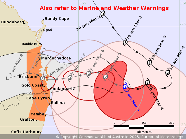
8.45 AM | More than 100 schools across NSW Northern Rivers region to close:
The NSW Education Department has confirmed 122 schools across the Northern Rivers have been closed today as the region braces for the arrival of Tropical Cyclone Alfred.
The closures, which stretch from the Queensland border to Yamba, will be in place from Wednesday March 5 to Friday March 7.
“We request families do not send your children to school for the next three days,” a spokesperson for the NSW Education Department said.
“Our school staff will be onsite this morning in case the message is not received in time”.
A full list of northern NSW school closures can be found here.
Gold Coast schools remain open at this stage, with a call to be made sometime today on whether or not they will be operational tomorrow.
8.30 AM | Multiple evacuation centres to open in NSW today:
The NSW Government has confirmed seven evacuation centres will be opening in the Northern Rivers area this afternoon.
The centres will be located in Kingscliff, Murwillumbah, Ocean Shores, Coraki, Kyogle, East Lismore, and Evans Head.
They will be open from 4pm, with further details available on the NSW SES website here.
LATEST @ 6.30AM, Wednesday March 5 | Tropical Cyclone Alfred has completed its u-turn and is now barreling towards the Southeast Queensland Coast, with the Gold Coast now directly in the firing line.
The Category Two system is currently sitting around 430 kilometres east of the Gold Coast and is expected to cross late Thursday or early Friday morning.
We’re being warned to brace for damaging wind gusts of up to 120 kilometers per hour, with the possibility of destructive wind gusts of up to 155km per hour from Thursday afternoon.
A dangerous storm tide may also occur along the coastal foreshore if the time of the cyclone crossing coincides with the high tide.
“Tides are likely to rise significantly above the highest high tide mark with damaging waves and dangerous inundation of coastal low-lying areas,” the Bureau of Meteorology said.
Abnormally high tides are likely to continue, causing minor flooding of coastal low-lying areas all the way between Sandy Cape and Grafton.
Damaging surf leading to significant beach erosion is likely, with a Coastal Hazard and Hazardous Surf Warning in place as all beaches across the southeast remain closed.
One of the main concerns for the Gold Coast is heavy rainfall and flash flooding, with six hourly rainfall totals between 200 and 250mm and 24-hour totals between 300 and 400mm possible on the southern side of the system
“These figures are dependent on the movement and position of the system,” BOM said.
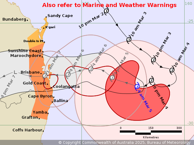
The Premier has warned today will be the last day for residents to get prepared.
“The decisions you make today are the most important ones that you will make during an event,” David Crisafulli said.
“If you take the time to remove those loose items, if you get the chance to remove those overhanging trees, the difference that makes to protect your home it’s a massive, massive difference”.
The Prime Minister has touched down in Queensland and will meet with the Premier this morning to discuss the State’s disaster plan.
The two leaders will hold talks alongside the state’s disaster coordination group at the State Emergency complex in Kedron around 8am local time.
Three evacuation centres will open on the Gold Coast tonight, with residents being told to decide now whether they plan on evacuating or bunkering down.
The centres will open at the following locations from 6pm Wednesday:
- Runaway Bay Indoor Sports Centre
- Nerang Bicentennial Centre
- Burleigh Waters Community Centre
LATEST @ 1500, Tuesday March 4 | City leaders are warning the Gold Coast will be the worst affected region as Tropical Cyclone Alfred starts making its way towards the Queensland coast.
Alfred remains a category two system about 600kms east of Brisbane with winds of 130k/h.
Forecasters are expected Alfred to make landfall just north of Brisbane either late on Thursday night or early Friday morning.
However, it is areas to the south of the cyclone that will cop the brunt of Alfred with the impact to be felt for several days.
“The greatest concern is for the City of the Gold Coast as opposed to any of the other local authorities,” Acting Mayor Donna Gates said.
“We’re expecting gale force winds on Thursday and Friday accompanied by very heavy rainfall which won’t ease until Sunday.”
Daily rainfall totals of up to 500mm are possible, especially in areas of the Hinterland.
Other parts of the city could be hit with more than 700mm over 72 hours.
The other threat facing the city is from storm surges, with Alfred’s arrival set to coincide with high tide.
“If the system crosses at high tide, it is a far more complex situation than if it crosses at low tide, and an added layer of complexity is high tide is in the middle of the night,” Premier David Crisafulli warned.
Council has released mapping of potential flood impacts across the city with areas including Paradise Point, Surfers Paradise and Elanora expected to be among the worst affected.
“It’s important to note that this is the very worst case scenario. It’s modelled on 600mm of rain,” Councillor Gates said.
The Acting Mayor said there are no plans to evacuate any suburbs at this stage, but is urging residents to check the Gold Coast Disaster Flood Risk Map on the Council Dashboard to be aware of the potential impacts.
Evacuation Centres
Council has confirmed three evacuation centres will be open from 6pm on Wednesday at the following locations:
- Runaway Bay Indoor Sports Centre
- Nerang Bicentennial Centre
- Burleigh Waters Community Centre
Residents are being urged to decide within the next 24 hours whether they plan to evacuate or ride out Alfred.
“We’re asking Gold Coasters to have a plan by 5 o’clock tomorrow afternoon (Wednesday). From 5 o’clock tomorrow afternoon, you should be starting to settle in and understanding where it is you are going to,” Mr Ryan said.
Sanbagging Stations
Sandbagging stations at Pimpama, Bilinga and Burleigh Heads will be open from 8am to 5pm.
- 196 Old Pacific Highway, Pimpama (next to the City of Gold Coast Coomera Depot)
- 42-44 Boyd Street, Bilinga (next to the City of Gold Coast Tugun Depot)
- 61 Hutchinson Street, Burleigh Heads (at the Reedy Creek Waste and Recycling Centre)
There are also self-serve depots open at Carrara and Tugun.
- Carrara Sports Precinct Parking (access via Alabaster Drive Carrara)
- 414 Coolangatta Road, Tugun (at the Tugun Village Community Centre)
Schools
Schools will remain open on Wednesday with a decision to be made tomorrow on whether they will close on Thursday.
Waste Collection
Council has cancelled scheduled waste collection on Thursday and Friday with residents urged not to put their bins out. The city’s waste centres will also be closed on Thursday and Friday.
Council Services
Non-essential council services including pools, libraries and community centres will be closed on Thursday with a decision to be made about Friday.
Events
Wednesday night’s Greenday concert, which was due to take place at CBus Stadium, has been cancelled. The Gold Coast Suns’ Opening Round clash at People First Stadium on Saturday, The Australian Women’s PGA, Queensland Surf Lifesaving Championships, The Australian Boardriders Battle have also been called off.